

Automated geoprocessing: when GIS stops being a tool and becomes operational infrastructure
Geospatial pipelines, spatial databases, feature APIs, COG, STAC catalogues and asynchronous processing: what changes when territorial analysis has to run over thousands of polygons instead of one.
Por Diretor Técnico · Geoespacial & Engenharia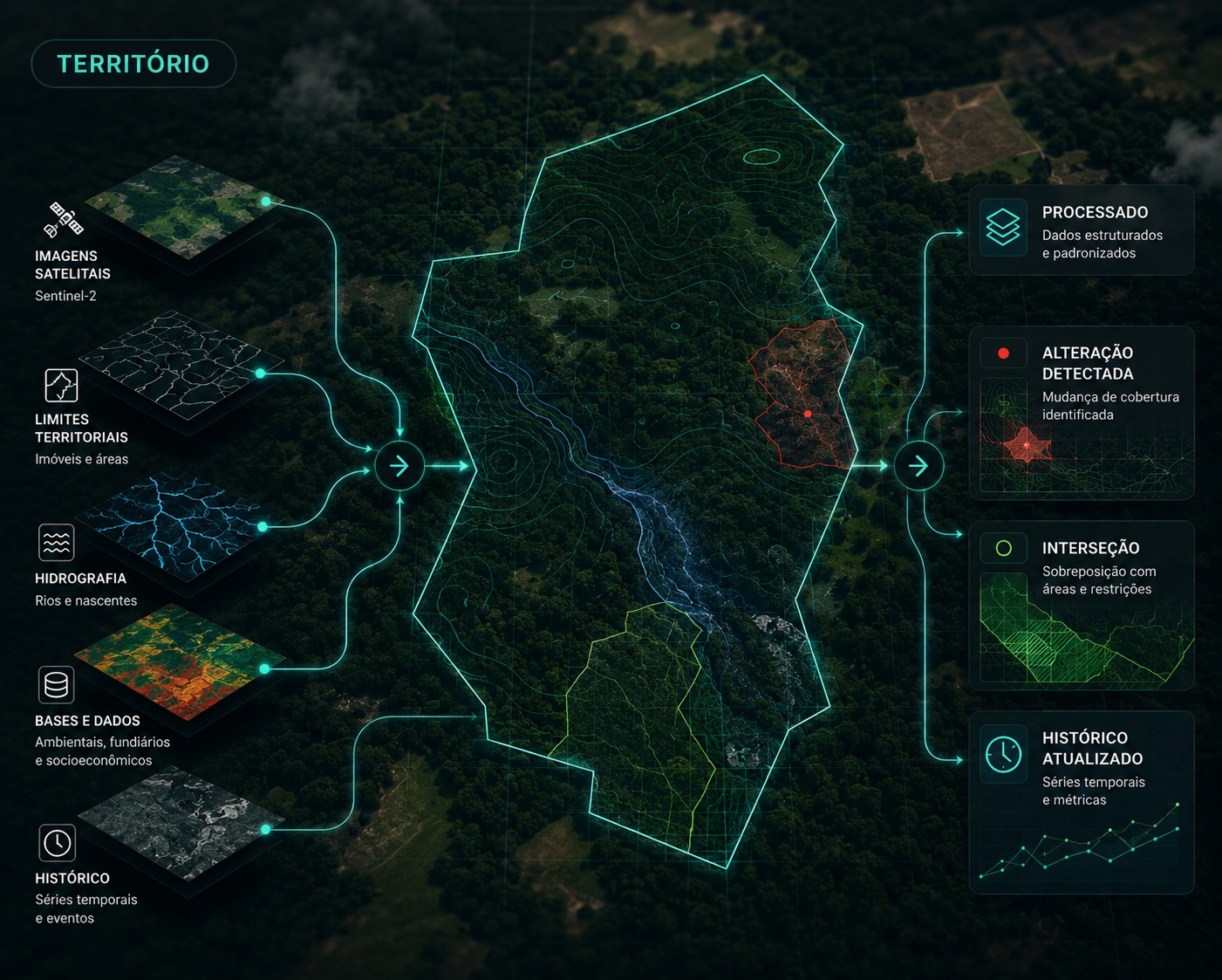
In short
- There is a practical difference between running a geographic analysis and building a geospatial operation that runs continuously.
- At scale, the polygon stops being a drawing on the map and starts working as an instruction that triggers processing.
- Spatial databases, feature APIs, COG and STAC catalogues let you query only the data you need instead of moving whole files.
- Automating geoprocessing includes handling invalid geometry, divergent projections, duplicates and cloudy scenes, not just running intersections.
- The interface can be simple because the complexity was solved before it reached the user.
For a long time, working with geoprocessing meant opening a GIS application, loading layers, running spatial operations and producing a map. That model is still useful for specific analyses. Even so, there is a significant difference between performing a geographic analysis and building a geospatial operation.
Take the boundary of one rural property. A professional opens the file, checks the geometry, reprojects it, crosses it with other datasets, calculates areas, queries imagery, generates indices, analyses land cover and produces a report. For one property that works. For ten, too. For fifty thousand, the problem stops being cartographic and becomes computational. That is where geoprocessing moves closer to software engineering and data architecture.
A polygon can be an instruction
For a geospatial system, a polygon does not have to be just a geometry displayed on a map. When a new area enters the platform, it can automatically trigger a sequence of checks. The user submits a geometry and the infrastructure works.
- Polygon received
- Spatial validationgeometry, projection, topology
- Territorial characterization
- Cross-check with reference datasets
- Query of temporal data
- Geospatial processing
- Identification of relevant conditions
- Structured result
What separates a geospatial pipeline from a GIS analysis?
In an analysis, the professional controls every step: picks the files, runs the processing, checks the result and starts the next operation. In a pipeline, the sequence is already defined and versioned, and the same rule that analyses one property analyses thousands. The question stops being how many clicks the analyst can perform and becomes how much processing the infrastructure orchestrates reliably.
Vector and raster as parts of the same system
Most territorial operations combine two universes. Properties, municipalities, roads, rivers, protected areas, stands and plots are usually represented by points, lines and polygons. Satellite imagery, digital terrain models, rainfall, temperature and vegetation indices are pixel grids. The potential appears when those structures stop being processed in isolation and a property is automatically related to land use and cover, vegetation history, terrain, hydrography, restrictions, time series and events detected by remote sensing.
The result stops being a map and becomes a territorial object enriched with information that other systems can query.
The database also needs to understand geography
In more advanced operations, coordinates do not live only inside files. The database itself understands geometry, which makes it possible to ask directly which properties intersect a given area, what share of a property falls inside a land use class, which polygons are within a certain distance of a river, which areas had recent cover change or which clients hold assets inside the region affected by an event.
Spatial information becomes part of the application logic, with no intermediate file produced for every question.
A map can be a real-time query
When information stops being distributed as closed files, systems start requesting only the elements needed for a given operation. The OGC API Features standard defines building blocks for accessing and querying geographic objects directly through web APIs, allowing granular work with features instead of transferring a complete dataset.
- Where is the shapefile?
- Transfer of the complete dataset
- Local copies that go stale
- One export per question
- Which objects meet this condition?
- Only the features needed
- A single source, always current
- The same base answers many questions
The same is happening with imagery
A satellite scene can take up hundreds of megabytes or several gigabytes. Downloading the whole file before any processing is usually unnecessary. The Cloud Optimized GeoTIFF, standardized by the OGC, uses internal data organization and HTTP range requests so the application reads only the parts of a remote raster it needs.
If a property occupies a small region of the scene, there is no need to move the entire image to analyse it. Multiplied by thousands of queries, that changes storage, traffic and processing time.
The image catalogue also has to be searchable
With thousands or millions of geospatial assets, storing is not enough: you need to discover which image matches the location, period and sensor of interest. The STAC specification creates a common structure for describing and searching spatial and temporal assets, associating geometry, date and related resources. Geoprocessing starts working with searchable catalogues instead of file directories.
A new image can start the processing
- New observation available
- Related areas are identified
- Processing runs
- The result is compared with the history
- Relevant changes are identified
- Only exceptions go to analysis
A spatial calculation can become a service
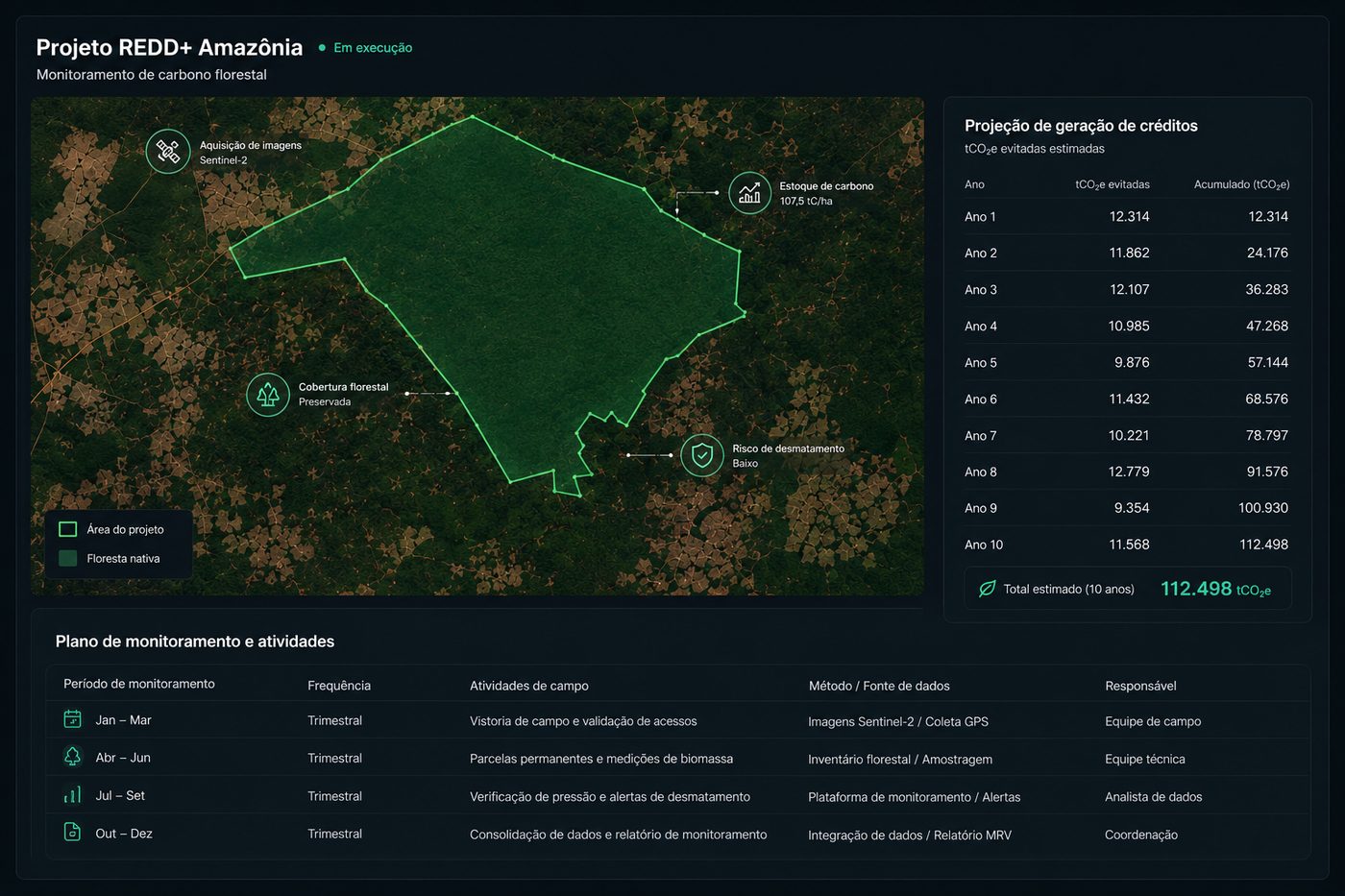
Consider a simple operation: receive a polygon and calculate territorial characteristics. At first an analyst does it manually. Then it becomes a script. Next, a routine. The routine is exposed to other systems and geoprocessing starts working as a computational service: a platform sends the geometry and receives a structured response.
The user does not need to know which spatial operations happened between the input and the response. They need to trust that the process is consistent and reproducible.
Scale changes the type of problem
With few areas, each exception is solved by hand. With thousands, small inconsistencies become system problems: invalid geometry, different coordinate systems, duplicated polygons, corrupted files, overlaps, missing data, cloudy imagery, poorly defined boundaries, resolution differences and operations that exceed the available computing capacity.
Not every processing job has to be immediate
A simple query returns in seconds. A temporal analysis with dozens of images takes longer. Processing over thousands of properties requires an execution queue. A well-structured system does not freeze while that happens: the request creates a processing job, execution runs in the background, steps are tracked, the result is stored and the user is notified.
Efficiency also comes from avoiding unnecessary work. If a source has not changed, there is no reason to process it again. If an image was already used, its result can be reused. If only one region of the territory changed, only that region needs recalculating. This logic brings geoprocessing closer to systems engineering.
Geoprocessing as a rules engine
The potential grows when spatial results feed decisions: if a given territorial condition is present, run an additional analysis; if there was a recent change, raise the priority; if there is an overlap with a given layer, request a review. The map starts taking part in the operational logic.
| Area | Possible application |
|---|---|
| Carbon | Eligibility, monitoring and cover change |
| Environmental | Restrictions, alerts and territorial follow-up |
| Forestry | Stands, inventories and cover evolution |
| Land tenure | Overlaps, boundaries and characterization |
| Rural credit | Territorial analysis of portfolios |
| Insurance | Geographic exposure and events |
| Infrastructure | Assets and spatial interference |
The interface can be simple because the complexity sits behind it
The user sees a map, a search field, a polygon, an indicator and an alert. Behind that screen there are spatial databases, vector and raster processing, image services, temporal catalogues, APIs, processing queues, geographic databases, rules engines and analytical models. The quality of a geospatial platform is not measured by the number of visible tools: a good solution usually looks simple because the complexity was solved before reaching the user.
The next leap for GIS is not producing better maps. Maps remain fundamental. The leap happens when territory becomes information that systems query, process and use continuously: a polygon starts a process, an image generates an event, a change creates an alert and a geographic base answers thousands of queries with no manual intervention.
That also changes the professional profile of the field. Projections, topology, geometries, raster, remote sensing and spatial analysis remain essential, and now live alongside databases, APIs, programming, web architecture, distributed processing and cloud computing. If someone hands over one polygon, almost any team can analyse it. When the same rule runs in a controlled, traceable and scalable way over a hundred thousand, it stops being a service and becomes technology.
Technical references
- OGC API Features, access and query of geographic features through a web API — Open Geospatial Consortium
- Cloud Optimized GeoTIFF, efficient reading of parts of remote rasters — Open Geospatial Consortium
- SpatioTemporal Asset Catalog (STAC), description and discovery of geospatial assets — STAC
- OGC API Common, reusable components for geospatial APIs — Open Geospatial Consortium
Especialista em processamento de dados geoespaciais e modelagem ambiental. Mais de 10 anos em projetos de carbono e inteligência territorial.
This topic is part of one of HIGGN's areas of work. See the related solution
Related content
Need to structure this process in your operation?
Share the technical context of your operation and we will come back with an initial analysis.
Request a diagnostic